
ST. PARIS – Graham High School students have been participating in a new program this year aimed at certifying students in operating tools that use Geographic Information System (GIS) mapping technology. Three students have been trained and are currently in the process of using the technology to map the Village of St. Paris by identifying the water features such as hydrants, valves, and curb boxes.
The students started the program last October, meeting Curtis Truss, from Operator Training Committee of Ohio, Inc., known as OTCO. Truss has assisted the students every step of the way to learn about the technology and its proper use. The students have been using mapping technology to provide 12-inch accuracy readings for all of the water features in St. Paris. They then upload the information to a web based program called IAmGIS in order to assist the water department in its efforts to troubleshoot issues, upgrade their system, and make services more efficient for residents.
“The technology used may be different than what George Washington used in this region centuries ago, but the concept is the same. From property boundaries to plumbing, mapping our world precisely is still an important and needed skill for communities. Business and services can’t happen without precise measurements,” GHS Principal Ryan Rismiller said.
The student team has volunteered well over 60 hours already to help with the marking of the features of the program. The students have been working directly with Spencer Mitchell of the Village of St. Paris. The students were sponsored by Curtis Truss to attend a regional training event for civil service employees called Water Workshop on March 6 in Columbus. Students had the opportunity to participate with leaders in the water industry and met with Tony Shriner, a leader on GIS and Asset Management.
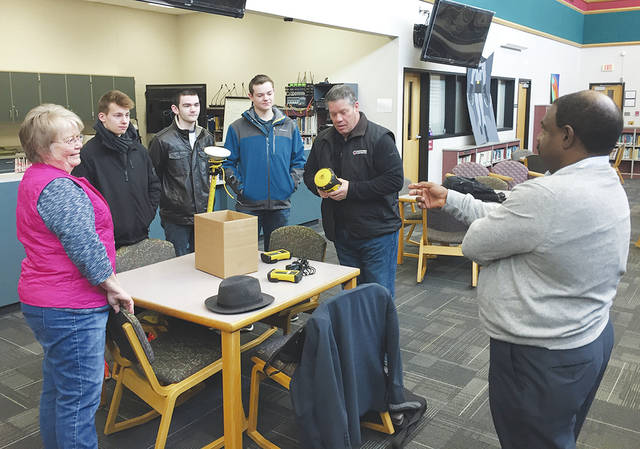
On April 2, the student team of Andrew Robeson, Alex Sparks, and Tim Hughes worked with Spencer Mitchell, Curtis Truss, Doug Kotnik of Precision Laser, and Saint Paris Mayor Brenda Cook as students participated in a webinar with Tony Shriner on the use of software like IamGIS, the value of modern surveying, and operations of the technology equipment.
Throughout this program, the use of surveying equipment from Precision Laser and OTCO, registration costs to the Water Workshop, and training in the use of the equipment have all been donated to GHS from its industry partners. Students will be able to use their new civil engineering credentials to pursue work after graduation – using modern tools to learn modern methods to help their communities.

