
A new tool to map properties in three dimensions is helping several county agencies do their jobs more efficiently.
Champaign County Auditor Karen Bailey began using Pictometry Eagleview in 2012 for that year’s reevaluation, and she found it useful for updating property tax data. She decided to continue to use it for the upcoming 2019 reevaluation and offered other county agencies access to it.
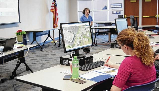
The program provides an online interface for looking at county properties from all angles, Bailey said. The images are taken from a flyover by an airplane at an angle, allowing those using the program to see more than just the top of a property. There is also a mobile application for users’ tablets and phones.
Bailey said it helps to determine improvements on a property, especially when overlaid with prior years’ images. Differences pop up visually, making it easy to determine if a barn was taken down, for example. Since residents don’t always update the auditor on changes to their homes or other buildings on their property, this saves the auditor time and staff.
“Since our county is mostly agricultural, we can measure barns, silos, lots, acreage, roof pitch.” she said. “There are lots of measuring tools. It’s a lesser amount of time to have to get in the car to drive to people’s houses (to do the appraisal).”
The county auditor’s website already has a mapping system, but it only shows two dimensions, meaning the tops of buildings. The Pictometry Eagleview program allows users to look at a property from different angles, to see how many stories a building is and entrances and exits to buildings, for example.
The program has more uses than just pictures and measurements. Images can be sent to someone out in the field who is going to a property, which can save time, Bailey said.
Use by other county, city workers
Bailey realized it might be just as useful for other county agencies, so she offered other county agencies access. She said she figured since it was paid for, there was no reason not to do so.
The program cost $72,259, Bailey said. That covers the cost of the flyover of the picture-taking airplane and online access to the images.
Pictometry Eagleview Presenter Laura Mondo trained agency representatives Tuesday and Wednesday on the program. Representatives in attendance were from a variety of agencies, including the Urbana Police Division, the Village of St. Paris, the 911 operations center, Champaign County Health District and others.
Champaign County 911 Center Director Vannessa Haley said she attended the training to learn more about the program, to see if it could supplement what the agency already uses. When 911 calls come in, they pinpoint the location on a map to help dispatchers and first responders locate the emergency.
“I am curious to see what else is out there, and would it work with what we have,” she said.
Haley added the program would allow them to provide latitude and longitude coordinates for CareFlight and MedFlight at a particular property. That data can help 911 clarify where the helicopters can land on a property.
Champaign County Treasurer Robin Edwards told Mondo she currently uses the auditor’s site to look at properties, for example, to determine if a tax delinquent property appears to have people living there. This program could give her more detailed information.
Urbana police officers told the group they tend to use mapping systems to look at a property to get more information as they consider seeking a warrant.
Deputy Auditor Molly Hairston said she also uses the program to get a clearer view of property lines. More detailed images from different angles can help a property owner better understand where their property ends so they don’t cross onto a neighbor’s property, she said.
Real Estate Department Director Sharon Bethel, also in the auditor’s office, uses it for measurements every day.
Bailey said the images from the program can be requested like any public document in her office. She is not putting it online, though some auditors have chosen to do that in other counties.

