
Urbana City Schools’ request for approval of its preliminary site plan for a pre-kindergarten through eighth-grade school at 550 Community Drive was tabled until next month by the Urbana Planning Commission on Monday.
After hearing from those involved with the project as well as from residents concerned about some of the details of the project, the seven-member Planning Commission unanimously agreed to hold off on a decision in favor of coming together for a work session at 6 p.m. on Nov. 16 to discuss the proposed site plan at greater lengths. A decision on the preliminary site plan is expected to be made at the Nov. 23 Planning Commission meeting set for 6 p.m. in the municipal building’s fire training room.
During Monday’s meeting, Michael Myers, project manager for Fanning Howey Associates (the firm hired by the school district to handle the project’s architectural work), stated approval is being sought for the preliminary site plan, not for the final design plan, which he expects to be completed next spring.
“The project is in the very early design stages,” he said.
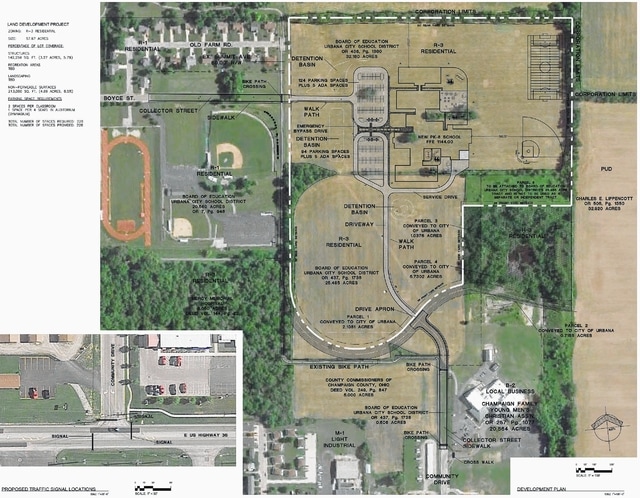
According to Myers, the plan is for the 180,000-square-foot elementary/junior high school building – expected to serve approximately 1,527 students – to be accessed from the south by Community Drive and from the west by Boyce Street.
Primary access
Community Drive, Myers said, is intended to serve as the main entrance to the school and will be used primarily by parents, event-goers, and by delivery and service vehicles.
To gauge the impact on the increased traffic in the area, a traffic study was conducted, and as a result, Urbana City Schools has agreed to pay for the installation of a traffic light.
“After review and discussion with the city, it was determined that in the city’s opinion, signalization is necessary at the intersection of Community Drive and U.S. Route 36, however, it’s only required during the peak hours of school operation – for drop off by parents in the morning and pickup in afternoon,” Myers said. “During other times of the day, the traffic signal at this location would be in flasher mode.”
As for construction details, Myers said, Community Drive will be extended as a collector street from its current terminus point near the Champaign Family YMCA north to what may one day be the intersection of the Washington Avenue extension. The Community Drive extension, he said, will be designed and built in accordance with city engineering standards as a collector street.
The rest of Community Drive from the end of the proposed collector street extension north to the school property will be an asphalt driveway, Myers said.
“We will be extending the water lines, the storm sewers, and gas and electrical services in that area,” he said. “Sanitary sewer has been requested to be extended by the city, however, the sanitary sewer on Community Drive is actually too shallow to service our school property based on grades of elevation on the school and the property there. So, it is not a connection point we can use.
“The sanitary sewer line on Community Drive is also outside of the road, so it could be extended up to the intersection at Washington Avenue in the future by others without having to tear the roadway out,” Myers added.
Along with the collector street, driveway and extension of utilities, the plan is to extend the sidewalks north along the east side of Community Drive from where the existing sidewalks end to the future Washington Avenue intersection. The plan calls for the area along the driveway to the school building to feature an asphalt walk path.
Second entrance
When it came to selecting a secondary access point into the proposed school site, Myers said, three different connection points were considered. They included Old Farm Road, Boyce Street and Washington Avenue.
While researching all three possible routes, Myers said, the decision was made to go with Boyce Street because the connection at Old Farm Road didn’t service the site well, and Washington Avenue was found to be a problem spot.
“One of the obstacles that we all know we are going to run into along (Washington Avenue) is that this is a very low, wooded area,” he said. “It may have wetlands and very poor soil conditions through the area. During initial evaluation of this (area), we saw very extreme costs in trying to mitigate some of the issues. Plus, it’s a very long length to get back to that connection point as well.
“Boyce Street already serves the athletic complex and has a more throughway connection as a collector street,” Myers added. “It is a more direct connection right into the site.”
The preliminary site plan calls for Boyce Street to be extended as a collector street east from its current terminus point near the Urbana City Schools Athletic Complex to the future intersection of Summit Avenue (an area running north and south from Old Farm Road to the southern portion of the school property that could one day be developed into a city street). From the site of the future Summit Avenue intersection east to the school, a driveway is planned leading to a staff/bus parking lot.
“This drive access is intended to be primarily for staff entrance and parking, and also for bus drop off and pickup,” Myers said. “Also on Boyce Street, we will be extending the water system, storm water system, and making our sewer connection to the area.
“We will be providing sidewalks to the south side of Boyce Street from the current drive access to the athletic complex over to Summit Avenue,” he added. “From there, it will be a walk path to the building.”
Myers said if funds are available, additional sidewalks on Boyce Street from the athletic complex west toward Dorothy Moore Avenue are a possibility.

